


LIBERTYVILLE 198 Voting District, Lake County, Illinois
About
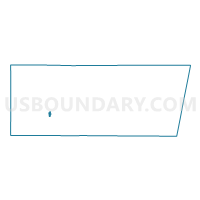
Outline

Summary
| Unique Area Identifier | 572230 |
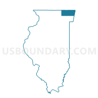
| Name | LIBERTYVILLE 198 Voting District |
| County | Lake County |
| State | Illinois |
| Area (square miles) | 0.66 |
| Land Area (square miles) | 0.61 |
| Water Area (square miles) | 0.04 |
| % of Land Area | 93.44 |
| % of Water Area | 6.56 |
| Latitude of the Internal Point | 42.25725090 |
| Longtitude of the Internal Point | -87.94091260 |
Maps

Graphs
Select a template below for downloading or customizing gragh for LIBERTYVILLE 198 Voting District, Lake County, Illinois


Neighbors
Neighoring Voting District (by Name) Neighboring Voting District on the Map
- LIBERTYVILLE 179 Voting District, Lake County, IL
- LIBERTYVILLE 180 Voting District, Lake County, IL
- LIBERTYVILLE 182 Voting District, Lake County, IL
- LIBERTYVILLE 192 Voting District, Lake County, IL
- LIBERTYVILLE 193 Voting District, Lake County, IL
- LIBERTYVILLE 196 Voting District, Lake County, IL
- LIBERTYVILLE 197 Voting District, Lake County, IL
- LIBERTYVILLE 473 Voting District, Lake County, IL
Top 10 Neighboring County Subdivision (by Population) Neighboring County Subdivision on the Map
Top 10 Neighboring Place (by Population) Neighboring Place on the Map
- Mundelein village, IL (31,064)
- Vernon Hills village, IL (25,113)
- Libertyville village, IL (20,315)
- Mettawa village, IL (547)
Top 10 Neighboring Elementary School District (by Population) Neighboring Elementary School District on the Map
- Hawthorn Community Consolidated School District 73, IL (29,650)
- Libertyville School District 70, IL (18,900)
Top 10 Neighboring Secondary School District (by Population) Neighboring Secondary School District on the Map
Top 10 Neighboring State Legislative District Lower Chamber (by Population) Neighboring State Legislative District Lower Chamber on the Map
Top 10 Neighboring State Legislative District Upper Chamber (by Population) Neighboring State Legislative District Upper Chamber on the Map
Top 10 Neighboring 111th Congressional District (by Population) Neighboring 111th Congressional District on the Map
Top 10 Neighboring Census Tract (by Population) Neighboring Census Tract on the Map
- Census Tract 8639.04, Lake County, IL (6,011)
- Census Tract 8639.02, Lake County, IL (5,533)
- Census Tract 8638.01, Lake County, IL (4,690)